

Construction Projects Near or On Campus
These are important summer 2026 construction projects to be aware of as you head to campus:
- The US-127 Corridor project impacts several exits surrounding Greater Lansing.
- Grand River Avenue (near campus) and Saginaw Highway (west of Lansing) roadwork include lane closures.
- I-96 construction (west of Lansing) includes lane closures.
- Campus Construction: Farm Lane, Wilson Road and Red Cedar Road are expected to reopen by August 21.
The MDOT Mi Drive Map is a help resource as you prepare to drive to East Lansing (select the construction layer). You also can view a live MSU Construction and Detour Map: https://apps.gis.msu.edu/construction/closures-and-detours/
The following provides guidance for how to enter campus and navigate to your neighborhood check-in location and unloading zone.
Directions by Neighborhood - 2026 Information
- Brody Neighborhood
Brody Neighborhood
Entering Campus
- From the South - Enter campus via US-127 at the Kalamazoo Exit #76. Take Homer Rd. north to Michigan Ave. heading east, turn south onto Harrison Rd.
- From the North - Enter campus via US-127 at Saginaw Exit #78, take Howard Ave. south to Michigan Ave. heading east, turn south onto Harrison Rd.
- From the East - Enter campus via WB I-96 to N US-127 at Kalamazoo Exit #76. Take Homer Rd. north to Michigan Ave heading east, turn south onto Harrison Rd.
- From the West - Enter campus via EB I-496 to N US-127 at Saginaw Exit #78, take Howard Ave. south to Michigan Ave heading east, turn south onto Harrison Rd.
.jpg)
Check-In Location
Brody Hall, Grotto
Unloading Procedure
Once directed to hall’s unloading area, vehicles are unloaded in parallel lines along the Brody Road loop before being directed to long-term parking.
- East Neighborhood and McDonel Hall
Entering Campus
- From the South- Enter campus via US-127 to Jolly/Dunkel Exit #11. Take Collins Rd. to Forest Rd. to Harrison Rd. to Mt Hope Rd. to Hagadorn Rd.
- From the North - Enter enter campus via US-127 at Saginaw Exit #78. Take Grand River Ave. to Hagadorn Rd.
- From the East - Enter campus via I-96 to Okemos Road Exit #110. Take Jolly Rd. to Hagadorn Rd. to Wilson Rd. or Shaw Ln.
- From the West - Enter campus via EB I-496 to US-127 to Jolly/Dunkel Exit #11. Take Collins Rd. to Forest Rd. to Harrison Rd. to Mt Hope Rd. to Hagadorn Rd.
.jpg)
Check-In Locations
- Akers Hall – West Akers Study Lounge
- Holmes Hall – West Holmes Study Lounge
- Hubbard Hall – North Hubbard Lobby
- McDonel Hall – East McDonel Service Center
Unloading Procedure - Akers, Holmes and McDonel
Vehicles enter unloading zone from marked entrance and are directed to back into a space on an angle. Once unloaded, driver is directed to long-term parking.
Unloading Procedure - Hubbard
Once directed to hall’s unloading area, vehicles are unloaded in parallel lines before being directed to long-term parking.
- North Neighborhood - MASP
Entering Campus
- From the South - Enter campus via US-127 to Trowbridge Exit #9. Take Trowbridge Rd. to Farm Ln. to Grand River Ave. to Bogue St.
- From the North - Enter campus via US-127 at Saginaw Exit #78. Take Grand River Ave. to Bogue St.
- From the East - Enter campus via I-96 to Okemos Rd. Exit #110. Take Okemos Rd. to Grand River Ave. to Bogue St.
- From the West - Enter campus via EB I-496 to N US-127 at Saginaw Exit #78. Take Grand River Ave. to Bogue St.
.jpg)
Check-In Locations
- Mason and Abbot – Abbot Service Center
- Snyder and Phillips – Snyder Service Center
Unloading Procedure
Vehicles will be directed to an unloading space in the courtyard grass before being directed to long-term parking.
- North Neighborhood - West Circle
North Neighborhood
Entering Campus
- From the South - Enter campus via US-127 at the Kalamazoo Exit #76. Take Homer Rd. north to Michigan Ave. heading east, to Delta Ct.
- From the North - Enter campus via US-127 to Saginaw St. Exit #78. Take Howard Ave. south to Michigan Ave., heading east to Delta Ct.
- From the East - Enter campus via WB I-96 to N US-127 at Kalamazoo Exit #76. Take Homer Rd. north to Michigan Ave. heading east, to Delta Ct.
- From the West - Enter campus via EB I-496 to N US-127 at Saginaw Exit #78. Take Howard Ave. south to Michigan Ave. heading east, to Delta Ct.
.jpg)
Check-In Location
Campbell Hall South Lounge
Unloading Procedure
Once directed to hall’s unloading area, vehicles are unloaded along Delta Court before being directed to long-term parking.
- River Trail Neighborhood - Owen, Shaw & Van Hoosen
Entering Campus
-
From the South - Enter campus via US-127 to Trowbridge Exit #9. Take Trowbridge Rd. to Farm Ln. to Shaw Ln., and, if applicable, to Bogue St.
-
From the North - Enter campus via US-127 at Saginaw Exit #78. Take Grand River Ave. to Farm Ln. to Shaw Ln., and, if applicable, Bogue St.
-
From the East - Enter campus by via I-96 to Okemos Rd. Exit #110. Take Jolly Rd. to Hagadorn Rd. to Shaw Ln., and, if applicable, Bogue St.
-
From the West - Enter campus via EB I-496 to N US-127 at Saginaw Exit #78. Take Grand River Ave. to Bogue St., or to Hagadorn Rd. to Shaw Ln.
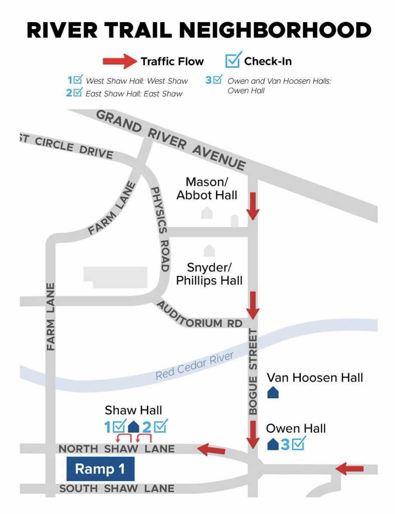
Check-In Locations
- West Shaw Hall – West Shaw Service Center
- East Shaw Hall – East Shaw Service Center
- Owen & Van Hoosen – Owen Hall Service Center
Unloading Procedure
Vehicles enter unloading zone from marked entrance and are directed to back into a space. Once unloaded, driver is directed to long-term parking.
-
- South Neighborhood
South Neighborhood
Entering Campus
- From the South - Enter campus via US-127 to Trowbridge Exit #9. Take Harrison Rd. north to Wilson Rd. or Shaw Ln.
- From the North - Enter campus via US-127 at Saginaw Exit #78. Take Howard Ave. south to Kalamazoo heading east. Turn south on Harrison Rd. to Wilson Rd. or Shaw Ln.
- From the East - Enter campus via WB I-96 to N US-127 to Trowbridge Exit #9. Take Harrison Rd. north to Wilson Rd. or Shaw Ln.
- From the West - Enter campus via EB I-496 to N US-127 to Kalamazoo Exit #76. Take Kalamazoo Rd east, turn south onto Harrison Rd., to Wilson Rd. or Shaw Ln.
.jpg)
Check-In Locations
- Case Hall – North Case Service Center
- Holden Hall – Holden Service Center
- Wilson Hall – East Wilson Service Center
- Wonders Hall – North Wonders Service Center
Unloading Procedure
Vehicles enter unloading zone from marked entrance and are directed to back into a space. Once unloaded, driver is directed to long-term parking.
A licensed driver must stay with the car at all times while it is unloaded. This ensures traffic moves quickly through the unloading zones, and if an emergency vehicle needs to enter, vehicles can be moved efficiently. Vehicles left unattended may be ticketed or towed.
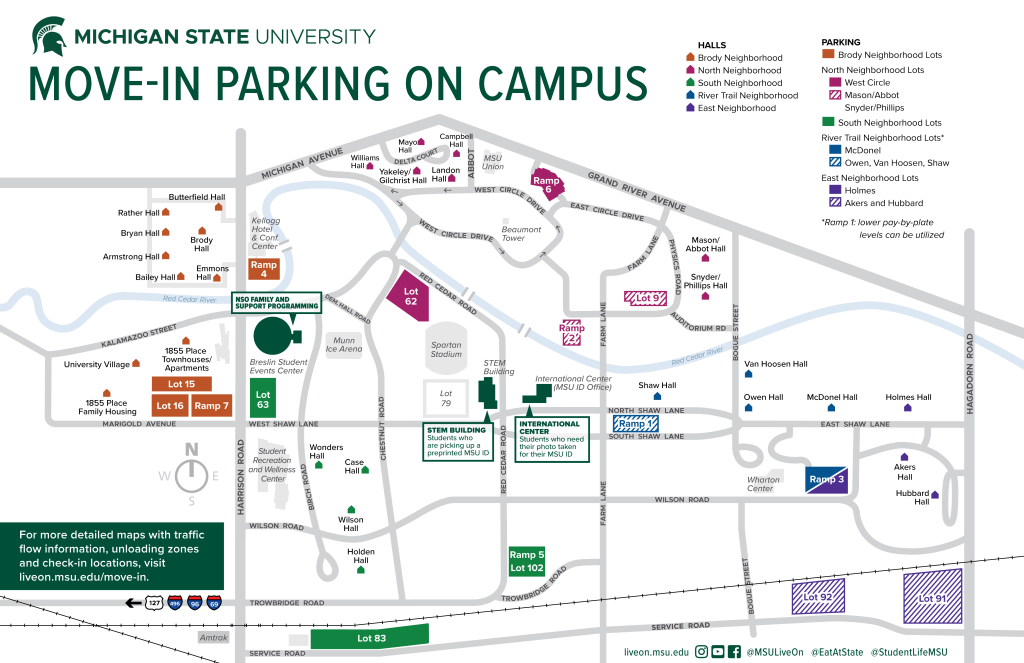
Long-Term Parking Map
Accessibility Needs and CATA Transportation
If you have accessibility needs, please let parking and unloading staff/volunteers know as you arrive and they will strive to assist you at the unloading zones. You will still be required to move your vehicle to long-term parking after unloading is complete. CATA bus routes will be running beginning August 18 for those who have accessibility needs, mobility concerns or prefer public transportation over walking. These can be viewed on the CATA website or on the Transit app.
The following CATA routes may be helpful by neighborhood. If long-term parking is full nearest your hall, please park in lot 89 and take route 32 to the transfer station at ramp 1.
- Brody Neighborhood. Park in Lot 89, take Route 32 to the Transfer Station at Ramp 1. Transfer to Route 31.
- East Neighborhood: From Lot 92, take Route 32 to the Transfer Station at Ramp 1. Transfer to Route 30.
- North Neighborhood - MASP: From Ramp 6 or Ramp 2, take Route 33.
- North Neighborhood - West Circle: From Lots 62/124, take Route 30 east to the Transfer Station at Ramp 1. Transfer to Route 33.
- River Trail Neighborhood: From Ramps 1 and 3, take Route 31. If needed, park in Lot 89, take Route 32 to the Transfer Station at Ramp 1. Transfer to Route 31.
- South Neighborhood: Park in Lot 89, take Route 32 to the Transfer Station at Ramp 1. Transfer to Route 33.
MSU App
We also recommend downloading the MSU App as we will share move-in steps and location pins for each residence hall the week of move-in.
Move-In Texting - 2026 Channel
Get the latest updates on move-in traffic, parking, and helpful tips delivered straight to your phone during move-in week! Sign up now by texting MOVEIN2026 to 888777 and stay informed for a smooth move-in experience. Message and data rates may apply.
2026 Check-In Locations
The check-in locations shared are for those checking in August 25-27. For other dates, go to the nearest open Service Center location.
